Zambezi River
The Zambezi River is one of Africa’s most significant waterways both in terms of its ecological importance and its cultural and economic impact on the surrounding regions. It is the fourth-longest river in Africa, spanning approximately 2,574 kilometers (1,599 miles) from its source to its mouth. The Zambezi River originates in the Mwinilunga District of northwestern Zambia, near the border with Angola. From there it flows through or forms the boundaries of six countries: Angola, Zambia, Namibia, Botswana, Zimbabwe, and Mozambique. The river ultimately empties into the Indian Ocean at the Mozambique Channel.History of the Zambezi River
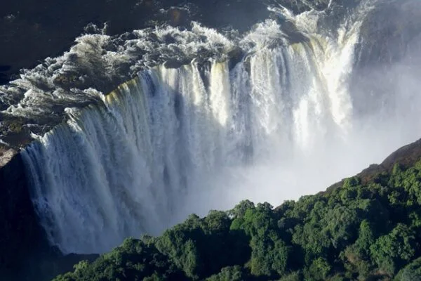
The name “Zambezi” has a history that is deeply intertwined with the cultures and languages of the indigenous people living along its banks. The word “Zambezi” is believed to have originated from the Tonga people, one of the ethnic groups that inhabit the regions surrounding the river. The Tonga word “yambezhi” translates to “great river” or “river of life,” reflecting the central role the river has played in the lives of local communities. For centuries, the Zambezi River has been a vital resource for the indigenous populations of Southern Africa. These communities relied on the river for fishing, agriculture, and transportation. The river also held spiritual significance, often being revered in local folklore and rituals. The name “yambezhi” thus encapsulated not just the physical presence of the river but its broader importance to the people. The Zambezi River first came to the attention of Europeans during the era of exploration and colonization in the 16th century. Portuguese explorers, traders, and missionaries were among the first Europeans to encounter the river, seeking routes to the interior of Africa. They adapted the local name to “Zambeze,” which later evolved into “Zambezi” in English. One of the most significant figures in the European exploration of the Zambezi was the Scottish missionary and explorer David Livingstone. In the mid-19th century, Livingstone undertook several expeditions along the river. His journeys and writings brought widespread attention to the Zambezi in Europe. Livingstone famously named Victoria Falls, one of the river’s most famous features, after Queen Victoria, although it was already known to the local Kololo tribe as “Mosi-oa-Tunya,” meaning “The Smoke That Thunders.” During the colonial period, the Zambezi River’s name became firmly established in European maps and documents. The river marked significant boundaries and played a key role in the geopolitics of the region. The name “Zambezi” was used consistently in various colonial languages, cementing its place in the historical and geographical lexicon. After the independence of the countries through which the Zambezi flows, the name remained unchanged. It continues to be a symbol of the natural heritage and cultural identity of the region. Today, the Zambezi River is celebrated not only for its ecological and economic importance but also for its rich historical legacy, encapsulated in its enduring name.The 3 sections of the Zambezi River
Upper Zambezi River
The Upper Zambezi River is the first major segment of the Zambezi River, stretching from its source in northwestern Zambia to the iconic Victoria Falls. This portion of the river is characterized by its relatively calm and gentle flow, and it traverses through diverse landscapes and ecosystems.Nyami Nyami: The River God
One of the most prominent figures in the folklore of the Upper Zambezi is Nyami Nyami, the river god. Nyami Nyami is often depicted as a serpent-like creature and is believed to reside in the Zambezi River. The Tonga people, who inhabit parts of Zambia and Zimbabwe, regard Nyami Nyami as a protector and provider. According to legend, Nyami Nyami can control the water levels and flow of the river thus influencing the success of fishing and agriculture. The construction of the Kariba Dam in the mid-20th century, which significantly altered the river’s flow led to stories of Nyami Nyami’s displeasure as earthquakes and floods were attributed to the god’s wrath. River Zambezi then moves eastwards and forms the boundary between Zambia and Namibia which is at Katima Mulilo rapids. It then meets with Chobe River and forms a border with Botswana before becoming a border between Zimbabwe and Zambia. This is where the four countries that is Namibia, Zimbabwe, Botswana and Zambia meet. The river then flows down towards the Victoria falls. This section is where tour operators run lots of exciting activities such as kayaking, canoe trips, river cruises and daily floats on both the Zimbabwe and Zambian sides. This is a spectacular section of the river with many islands and channels, crystal clear waters and sandy beaches. It teams with birds and wildlife. The Zimbabwe side is a national park called the Zambezi National Park whilst on the Zambian side there are many small lodges which blend into the banks of the river, plus about 20kms of the river’s shoreline lies within the Mosi-oa-Tunya National Park.Middle Zambezi
The Middle Zambezi River is a crucial segment of the Zambezi River, characterized by its dramatic landscapes, significant hydroelectric developments, and rich biodiversity. This section stretches from Victoria Falls to Lake Cahora Bassa in Mozambique. The Middle Zambezi is known for its powerful flow, deep gorges, and large reservoirs, making it both a natural wonder and a vital resource for the surrounding regions. The Victoria falls are taken as the boundaries between the upper river and middle Zambezi. The river serves as the border between Zambia and Zimbabwe then below the falls the river flows east cutting through gorges of basalt Rock between 200 to 250 meters. Within the gorges, its where the commercial white-water rafting takes place. The falls serve as a backdrop for other adventure sports as well as bungee jump from the Victoria falls bridge. The Kariba Dam was completed in 1959, is one of the largest man-made lakes in the world. The hydroelectric power generated at the dam provides electricity for much of Zambia and Zimbabwe. Lake Kariba is 226 km long and in places up to 40 km wide and supports a thriving commercial fishing industry and is a fantastic tourist attraction.The lower Zambezi
The Lower Zambezi River is the final stretch of the Zambezi River, extending from Lake Cahora Bassa in Mozambique to its delta at the Indian Ocean. This segment is characterized by its braided channels, lush floodplains, and the expansive Zambezi Delta, making it a region of great ecological significance and economic importance. The Lower Zambezi begins at the Cahora Bassa Dam, one of Africa’s largest dams, which was constructed in the early 1970s. The lake formed by the dam is a critical source of hydroelectric power for Mozambique and contributes significantly to the country’s energy supply. From Lake Cahora Bassa, the river flows southeast through Mozambique. The landscape changes from rugged gorges to wide floodplains, with numerous tributaries joining the main river. As the Zambezi approaches the coast, it becomes increasingly braided, forming an extensive network of channels and islands. Elsewhere it flows gently with many small channels to explore along the way. The river bed is sandy, and the banks are low and reed-fringed, however during the rainy season these streams join to become one fast flowing river. Therefore, the name “Zambezi” has a rich history that reflects the river’s importance to the indigenous peoples of Southern Africa, its encounter with European explorers, and its role in the colonial and post-colonial history of the region. The name remains a testament to the river’s enduring significance across cultures and generations.Read About
8 Must See Attractions in Uganda
8 Most Dangerous Animals on an African Safari
some of our tour packages


